


Über uns
Erstellen verwertbarer Daten aus Drohnen-Luftbildern.
Ian Titchener, Chief UAS Pilot and Aerial Mapping Specialist
Ian Titchener is a recognised authority in aerial surveying and unmanned aviation, with more than 14 years’ experience specialising in UAV mapping, surveying and photogrammetry.
Throughout his career, Ian has worked both directly with clients and as a specialist subcontractor, supporting some of the largest surveying companies in the UK on a wide range of projects. This experience has given him an in-depth understanding of the demands of professional surveying, construction and engineering environments, as well as the standards required to deliver reliable, survey-grade data.
His technical experience spans aerial mapping, LiDAR, photogrammetry, 3D modelling, earthworks and specialist geospatial data capture. Ian has operated and worked with advanced UAV platforms and sensors, selecting the appropriate technology and methodology to achieve accurate and commercially useful results.
In addition to his practical surveying experience, Ian has extensive experience in UAS training and operational compliance. He has delivered specialist training in aerial mapping, surveying and photogrammetry and has helped develop professional standards and best practice within the unmanned aviation sector.
Through UAV Surveys, Ian provides clients with access to this combination of specialist UAV knowledge, surveying experience and practical project understanding. Whether undertaking aerial mapping, LiDAR surveys, photogrammetry, earthworks modelling or specialist aerial data capture, his focus is on delivering accurate, dependable information that can be used confidently within wider surveying, engineering and construction workflows.
With experience ranging from individual site surveys to supporting major surveying organisations, Ian brings the technical expertise and practical understanding required to make UAV technology a valuable part of the modern surveying process.
Thomas Smith, Senior UAS Pilot and Aerial Mapping Specialist
Thomas Smith brings a strong technical background in civil engineering, wind turbine inspection and offshore operations to UAV Surveys.
With experience across demanding engineering and industrial environments, Thomas has developed a practical understanding of infrastructure, structural condition and the challenges associated with inspecting assets in difficult or inaccessible locations. His background in wind turbine inspection has provided extensive exposure to large-scale renewable energy infrastructure, where detailed, reliable data is essential for effective asset management and maintenance.
His offshore experience has further developed his understanding of working safely and efficiently within complex operational environments, where planning, risk management and attention to detail are critical.
At UAV Surveys, Thomas combines this engineering and operational experience with modern UAV technology to support the collection of high-quality aerial data for inspection, surveying and asset-management applications.
His practical approach enables UAV Surveys to understand not only how to capture data, but how that information can be used within wider engineering and asset-management workflows to help clients make informed decisions about their infrastructure.
Our Aircraft

DJI M400 RTK
With LiDAR, Photogrammetry and Thermography capability
DJI Mavic 3 Enterprise
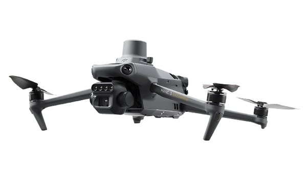
With photogrammetric and Multispectral Capability

DJI M210 RTK
With LiDAR, Photogrammetry and Thermography capability
Unsere Aufgabe
Bereitstellung raumbezogener Informationen mit intelligenten Luftbildern
Die 3D-Visualisierung von Drohnen bietet erhebliche Vorteile gegenüber herkömmlichen 2D-Bildern oder Karten, da sie eine immersivere und genauere Darstellung der realen Umgebung bietet. Es ermöglicht detaillierte Inspektionen, Messungen und Analysen von Objekten oder Strukturen aus verschiedenen Winkeln und Perspektiven und trägt so zu einem besseren Verständnis und einer besseren Entscheidungsfindung bei.
Unser Ziel ist es, diese wichtigen Daten zu sammeln, zu verarbeiten und Ihnen zur Verfügung zu stellen, um sicherzustellen, dass sie sowohl präzise als auch korrekt sind
Unsere Flotte modernster Luftsensortechnologie ermöglicht es uns, Ihre Daten zeiteffizienter und genauer bereitzustellen, sodass Sie Ihre Kunden im Rahmen des Budgets und pünktlich beliefern können.
