


About Us
Creating actionable data from drone aerial imaging.
Ian Titchener, Chief UAS Pilot and Aerial Mapping Specialist
Ian Titchener is a recognised authority in aerial surveying and unmanned aviation, with more than 14 years’ experience specialising in UAV mapping, surveying and photogrammetry.
Throughout his career, Ian has worked both directly with clients and as a specialist subcontractor, supporting some of the largest surveying companies in the UK on a wide range of projects. This experience has given him an in-depth understanding of the demands of professional surveying, construction and engineering environments, as well as the standards required to deliver reliable, survey-grade data.
His technical experience spans aerial mapping, LiDAR, photogrammetry, 3D modelling, earthworks and specialist geospatial data capture. Ian has operated and worked with advanced UAV platforms and sensors, selecting the appropriate technology and methodology to achieve accurate and commercially useful results.
In addition to his practical surveying experience, Ian has extensive experience in UAS training and operational compliance. He has delivered specialist training in aerial mapping, surveying and photogrammetry and has helped develop professional standards and best practice within the unmanned aviation sector.
Through UAV Surveys, Ian provides clients with access to this combination of specialist UAV knowledge, surveying experience and practical project understanding. Whether undertaking aerial mapping, LiDAR surveys, photogrammetry, earthworks modelling or specialist aerial data capture, his focus is on delivering accurate, dependable information that can be used confidently within wider surveying, engineering and construction workflows.
With experience ranging from individual site surveys to supporting major surveying organisations, Ian brings the technical expertise and practical understanding required to make UAV technology a valuable part of the modern surveying process.
Thomas Smith, Senior UAS Pilot and Aerial Mapping Specialist
Thomas Smith brings a strong technical background in civil engineering, wind turbine inspection and offshore operations to UAV Surveys.
With experience across demanding engineering and industrial environments, Thomas has developed a practical understanding of infrastructure, structural condition and the challenges associated with inspecting assets in difficult or inaccessible locations. His background in wind turbine inspection has provided extensive exposure to large-scale renewable energy infrastructure, where detailed, reliable data is essential for effective asset management and maintenance.
His offshore experience has further developed his understanding of working safely and efficiently within complex operational environments, where planning, risk management and attention to detail are critical.
At UAV Surveys, Thomas combines this engineering and operational experience with modern UAV technology to support the collection of high-quality aerial data for inspection, surveying and asset-management applications.
His practical approach enables UAV Surveys to understand not only how to capture data, but how that information can be used within wider engineering and asset-management workflows to help clients make informed decisions about their infrastructure.
Our Aircraft

DJI M400 RTK
With LiDAR, Photogrammetry and Thermography capability
DJI Mavic 3 Enterprise
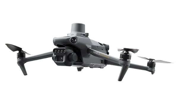
With photogrammetric and Multispectral Capability

DJI M210 RTK
With LiDAR, Photogrammetry and Thermography capability
Our Mission
Delivering geospatial truth with intelligent aerial imaging
Elevate your projects with our cutting-edge drone services in mapping, surveying, and photogrammetry. At UAV Surveys UK, we harness the latest technology to provide accurate and comprehensive geospatial solutions.
Drone Mapping: Our high-resolution drone mapping services enable precise terrain modelling, site analysis, and 3D mapping. Gain valuable insights for construction, agriculture, and environmental management.
Surveying: Experience efficient and cost-effective land surveying with our drone technology. We offer detailed land surveys, topographic mapping, and boundary assessments, saving you time and resources.
Photogrammetry: Explore the world from a new perspective with our photogrammetry services. Transform aerial imagery into detailed 3D models and orthomosaic maps for diverse applications.
Why Choose Aerial Surveys UK?
-
Experienced professionals and certified drone pilots
-
State-of-the-art drone technology for unparalleled accuracy
-
Customised solutions tailored to your specific needs
-
Timely project delivery and competitive pricing
-
Join industry leaders who trust us for their geospatial needs. Contact info@uav-surveys.co.uk to learn more about how our drone mapping, surveying, and photogrammetry services can enhance your projects.
