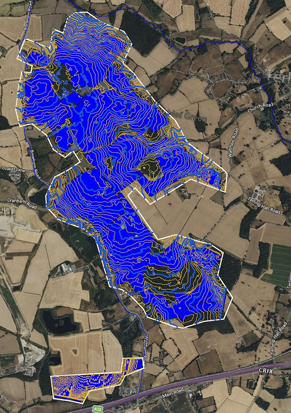
Aerial Mapping
Professional Drone Aerial Mapping
UAV Surveys UK provides professional aerial mapping services across the UK using drones, LiDAR and photogrammetry.
Aerial mapping provides a detailed digital representation of land, sites, structures and infrastructure. Depending on the project requirements, surveys can produce high-resolution orthomosaics, 3D point clouds, elevation models, contours and other spatial datasets for use in surveying, engineering, construction, planning and asset management.
Our aerial mapping services can cover individual sites through to large areas, with the survey methodology selected according to the terrain, vegetation, required accuracy, site conditions and intended use of the data.
What is Aerial Mapping?
Aerial mapping uses data captured from an aircraft to create geographically referenced maps and three-dimensional datasets.
Modern UAV systems can collect high-resolution imagery, LiDAR measurements and other spatial information while covering areas that may be time-consuming or difficult to survey entirely from the ground.
Aerial mapping can be used to produce:
-
Orthomosaic maps
-
Topographical maps
-
Digital Terrain Models
-
Digital Surface Models
-
LiDAR point clouds
-
Photogrammetric point clouds
-
Contours
-
Elevation maps
-
3D models
-
CAD and GIS datasets
The appropriate combination of sensors and survey methods depends on the requirements of each project.
Drone Aerial Mapping
UAVs provide an efficient method of collecting detailed spatial data across many different types of site.
Drone aerial mapping can be particularly useful for:
-
Development sites
-
Construction projects
-
Infrastructure
-
Roads and railways
-
Quarries and aggregates
-
Solar farms
-
Agriculture
-
Forestry and woodland
-
Utilities
-
Industrial sites
-
Environmental projects
-
Large areas of land
Aerial data can also provide a visual record of the site at the time of survey, making repeat surveys useful for monitoring change and construction progress.
Photogrammetric Aerial Mapping
Drone photogrammetry uses overlapping aerial photographs to reconstruct the three-dimensional geometry of a site.
The resulting imagery can be processed into a geographically referenced orthomosaic as well as a dense three-dimensional point cloud.
Typical outputs include:
-
Orthomosaic imagery
-
Dense point clouds
-
Digital Surface Models
-
Digital Terrain Models
-
3D meshes
-
Contours
-
Elevation data
-
CAD and GIS datasets
Photogrammetry is particularly useful where detailed visual information is required alongside spatial and three-dimensional data.
See our Drone Photogrammetry service for more information.
LiDAR Aerial Mapping
Drone LiDAR uses laser measurements to capture three-dimensional information about the surveyed environment.
LiDAR can be particularly useful for mapping terrain and complex sites, including areas where vegetation or other conditions can make photogrammetric ground reconstruction more difficult.
LiDAR mapping can produce:
-
Classified point clouds
-
Ground point data
-
Digital Terrain Models
-
Digital Surface Models
-
Contours
-
Elevation rasters
-
3D terrain models
-
CAD and GIS datasets
LiDAR and aerial imagery can also be collected together where a project requires both detailed terrain information and high-resolution visual data.
See our LiDAR Surveys service for more information.
Topographical Aerial Mapping
Aerial mapping can form the basis of a detailed topographical survey.
Ground levels and visible site features can be mapped from the aerial dataset and combined with GNSS ground control or conventional survey measurements where required.
A topographical aerial mapping project may include:
-
Ground levels
-
Contours
-
Spot heights
-
Buildings
-
Roads and paths
-
Hardstanding
-
Fences and walls
-
Drainage features
-
Earthworks
-
Vegetation
-
Other visible site features
The final dataset can be supplied in formats suitable for engineering, design, planning, construction and GIS applications.
Orthomosaic Mapping
An orthomosaic is a geometrically corrected aerial image created by combining multiple photographs.
The resulting map provides a continuous aerial view of the surveyed area while accounting for perspective and terrain effects.
Orthomosaics can be used for:
-
Site plans
-
Development projects
-
Construction records
-
Land management
-
Agriculture
-
Environmental monitoring
-
Infrastructure records
-
Asset management
-
GIS mapping
The resolution of an orthomosaic is determined by factors including the camera, flight height, image quality, ground sampling distance and survey conditions.
Large Area Aerial Mapping
UAV aerial mapping can be used to survey substantial areas efficiently, subject to the requirements of the project and applicable operational constraints.
Large-area surveys can provide a consistent dataset across:
-
Development land
-
Agricultural estates
-
Quarries
-
Solar farms
-
Infrastructure corridors
-
Forestry
-
Construction projects
-
Industrial sites
Survey planning considers the required coverage, ground resolution, terrain, airspace, weather, control requirements and final deliverables.
For particularly large or complex projects, a combination of aerial and ground surveying may be appropriate.
Construction Aerial Mapping
Regular aerial surveys can provide an accurate visual and spatial record of construction sites.
Repeat surveys allow changes in the site to be monitored throughout a project.
Applications include:
-
Pre-construction surveys
-
Existing site mapping
-
Construction progress
-
Earthworks monitoring
-
Cut-and-fill calculations
-
Stockpile measurement
-
Site documentation
-
As-built information
-
Contractor progress records
The same survey data can also provide orthomosaics, point clouds and elevation models for use by different members of the project team.
Infrastructure Aerial Mapping
Aerial mapping can be applied to a wide range of infrastructure projects.
Applications include mapping:
-
Roads
-
Railways
-
Bridges
-
Embankments
-
Utilities
-
Pipelines
-
Industrial facilities
-
Renewable energy sites
-
Drainage infrastructure
-
Large structures
Linear and distributed infrastructure can benefit from repeat aerial surveys, particularly where changes need to be monitored over time.
Where required, aerial data can be supplemented with ground GNSS measurements and other survey techniques.
Agriculture and Environmental Mapping
Aerial mapping provides an efficient method of recording large areas of land.
Applications can include:
-
Agricultural land mapping
-
Field boundaries
-
Drainage assessment
-
Terrain modelling
-
Environmental monitoring
-
Vegetation mapping
-
Woodland surveys
-
Land management
-
Habitat monitoring
LiDAR can provide additional information about terrain and ground structure in suitable vegetation and woodland environments.
The effectiveness of any aerial mapping method depends on the characteristics of the site, vegetation, season, sensor and required outputs.
GNSS Ground Control
Ground control can be used to establish the relationship between aerial survey data and the required survey coordinate system.
Where appropriate, ground control points and independent check points can be measured using GNSS surveying equipment.
Control requirements depend on the survey specification, site characteristics, sensor, processing methodology and required accuracy.
Independent check points can also provide a means of assessing the resulting dataset against known survey positions.
We establish the appropriate control methodology based on the requirements of the individual project rather than applying a single standard to every survey.
Aerial Mapping Accuracy
The achievable accuracy of an aerial mapping project depends on a combination of factors.
These can include:
-
Survey equipment
-
Sensor type
-
Flight height
-
Image resolution
-
Ground sampling distance
-
Image overlap
-
GNSS positioning
-
Ground control
-
Check points
-
Terrain
-
Vegetation
-
Weather
-
Processing methodology
-
Coordinate reference system
For this reason, accuracy should be specified against the requirements of the individual project.
Where survey accuracy is critical, control and independent check points can be incorporated into the survey design and quality assurance process.
Aerial Mapping Deliverables
We can provide aerial mapping data in a range of formats according to the requirements of the project.
Typical deliverables include:
-
Orthomosaic imagery
-
GeoTIFF imagery
-
Digital Terrain Models
-
Digital Surface Models
-
Classified LiDAR point clouds
-
Photogrammetric point clouds
-
LAS and LAZ files
-
Contours
-
Spot heights
-
3D models
-
3D meshes
-
CAD drawings
-
GIS datasets
-
Elevation rasters
-
Cross-sections
-
Volumetric calculations
-
Survey reports
Deliverables can be structured for use within CAD, GIS, engineering, design and construction workflows.
Aerial Mapping and 3D Data
Modern aerial surveys can provide considerably more than a traditional aerial photograph.
The captured data can be processed into three-dimensional datasets that allow users to measure, model and analyse the surveyed environment.
Point clouds, terrain models and 3D meshes can be used for:
-
Engineering design
-
Site analysis
-
3D visualisation
-
Digital twins
-
Asset management
-
Construction monitoring
-
Volumetric calculations
-
Terrain analysis
Where appropriate, aerial mapping can therefore form part of a wider geospatial data collection and reality capture project.
Our Aerial Mapping Workflow
1. Project Assessment
We review the survey area, terrain, vegetation, required accuracy, airspace, access and intended use of the data.
2. Survey Planning
The appropriate UAV, sensor, flight parameters, control and data collection methodology are selected.
3. Ground Control
Ground control and independent check points are established where required.
4. Aerial Data Capture
The site is surveyed using photogrammetry, LiDAR or a combination of technologies.
5. Data Processing
The captured data is processed into the required mapping and three-dimensional datasets.
6. Quality Assurance
The completed survey is checked against the project requirements and available survey control.
7. Data Delivery
The final mapping and survey data is supplied in the agreed formats.
Why Use UAV Aerial Mapping?
Aerial mapping can provide several practical benefits compared with relying entirely on ground-based data collection.
It can provide:
-
Rapid coverage of large areas
-
Detailed aerial imagery
-
Three-dimensional survey data
-
Repeatable surveys
-
Reduced requirement for ground access
-
Consistent site records
-
Multiple data outputs from a single survey
-
Integration with CAD and GIS workflows
The most appropriate survey method depends on the project. In some circumstances, conventional ground surveying remains the most suitable approach. Aerial and ground survey methods can also be combined where this provides a more complete dataset.
UK-Wide Aerial Mapping Services
UAV Surveys UK provides professional aerial mapping services throughout the UK.
We work with clients across construction, engineering, infrastructure, utilities, agriculture, development and environmental sectors.
Whether you require an orthomosaic, topographical map, LiDAR dataset, photogrammetric point cloud, terrain model or complete aerial survey, we can assess your requirements and recommend an appropriate survey methodology.
Request an Aerial Mapping Survey
If you require aerial mapping for a construction, engineering, development, infrastructure or land project, contact UAV Surveys UK to discuss your requirements.
Telephone: 01223 944646
Email: info@uav-surveys.co.uk
We can discuss the survey area, required accuracy, mapping methodology, control requirements and final deliverables before providing a quotation.